A Short History of the William Bucklin 600 Acres in Rhode Island
The first European settlers in Rhode Island were (in chorological order) John Hazel, William Blackstone, Roger Williams and his group, Samuel Neuman and his congregation, and William Bucklin.
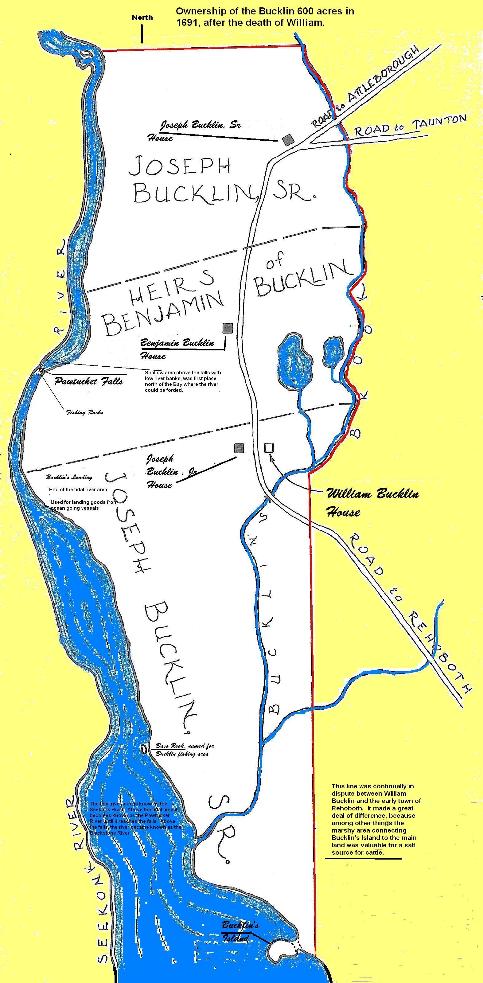
Bucklin owned a large 600 acre plot of land in the best location at Pawtucket falls. Hence, the history of the east side of the Pawtucket falls, and the area of commerce for that side of the river, from 1640 to 1800, is mainly that of William Bucklin and his descendants.
John Hazel – Original Settler of the 600 Acres
 The first European settler on the east side of the Pawtucket River probably was John Hazel. He chose the prime location of the falls and for a mile downstream, which had various transportation and farming advantages. The river served as a long-standing boundary between the Wampanoag and Narragansett Indian tribes. It was at the falls that major overland trails converged to cross the river. It was here that the Indians gathered to fish for salmon, alewives and shad which ran in abundance to the falls. The southerly end of the land was at present Bucklin’s Island, the only real place for easy access to the salt marsh grasses and ample points for a canoe to easily land supplies.
Hazel may have purchased his land directly from Osamequin, the Wampanoag sachem. He lived at peace with the Indians. Hazel probably was on the land before Blackstone or the Roger Williams party arrived a few miles downstream.
William Blackstone – a man of intelligence and a lover of quiet – north of the 600 acres
Next to arrive in the area was the Rev. William Blackstone. He choose land north of Hazel, in what is today’s Lonsdale section of the town of Cumberland. The southerly edge of his property was described as the “second wading place north of the falls” which was a reference to the point upstream from the falls that are now known as the Valley Falls. Blackstone built his home on a hill overlooking a wide bend in the Pawtucket River, naming it “Study Hill” He lived there for 40 years, where he — in great solitude — tended cattle, planted gardens, and read his books.
Blackstone has been described as an extremely well educated hermit. Rev. William Blackstone received a master’s degree from Cambridge University in 1621, and became an ordained priest of the Church of England (Anglican Church) Unhappy with the way the Anglican Church was being directed at the time, he joined an expedition which sailed to New England in 1623. The expedition was unsuccessful in founding a permanent settlement and most of the expedition returned to England, Blackstone remained and settled in solitude at what is now Boston’s Beacon Hill, with a library of books said to be one of the most extensive collections of books by a private person in England.
When the Massachusetts Bay Colony arrived with the Winthrop fleet, Blackstone invited them to his Boston area. But Blackstone did not like the colonist’s intolerance of variations in religious doctrine and services. That’s when he moved to his Study Hill, north of Hazel.
It is interesting to note that when Roger Williams subsequently arrived in Rhode Island, Blackstone became good friends with Roger Williams. They disagreed on theological matters, both agreed on the right to respectfully disagree. Indeed Baptist Williams invited Anglican Blackstone to regularly preach to the Williams group in Providence.
Settlers South of the 600 Acres
Roger Williams fled the Massachusetts Bay Colony to settle south of Hazel’s 600 acres. Roger William’s “Seekonk” settlement, on the east side of the Pawtucket River, was named by him “Rehoboth.”, The Rehoboth settlement was short lived. It ended when the Plymouth Colony forced him from this land. Williams then went to the west from the Pawtucket river to settle in what is now Providence.
Successive Settlers South of the 600 Acres
Although Williams left the east side of the Pawtucket River, Hazel remained at the strategic falls. Subsequently, in 1638, Rev. Thomas James, another dissident of the Massachusetts Bay colony arrived with his followers to start the second Seekonk settlement. This second Seekonk settlement shared the fate of the Roger Williams settlement and was short lived. Again, this was due to the actions of the Plymouth Colony after it discovered that people were living there without authorization or title from the Colony. The Colony wanted these non-conformists off land the Colony claimed was in its land grant from the king. The1638 planters (with the exception of planter Robert Morris) were forced to leave Seekonk. Hazel again remained after this second attempt to plant a community on the East side of the river. Perhaps the Plymouth Colony recognized him as a valuable contact with the Indians and as having purchased land from the Indians prior to the coming of the various Seekonk settlements.
Another Try at Settling South of the 600 Acres
The third settlement of this area occurred in 1643 when Rev. Samuel Newman moved with a considerable number of his parishioners from Weymouth to the Roger Williams’ Rehoboth location. Newman had religious problems in the Massachusetts Bay Colony, but none on purchase of the site. Rev. Newman was the first person in the area who had the foresight to seek political settlement with the Plymouth Colony before moving into the area. Unlike Williams, Newman secured permission to take his congregation (the group was one that disagreed with the established church of the Massachusetts Bay Colony) and move to the east shore of the Narragansett Bay. Unlike Williams, Newman purchased his land (eight square miles) from the Plymouth Colony, and had the land surveyed with title to him
But, like Williams, Newman thought it morally correct to purchase land from the Indians, rather than just assert the land title granted him by the colony. Newman made a second purchase of the same land for his settlement from Osamequin, a purchase which took place in the home of Roger Williams with John Hazel as a witness. This third settlement in about the same location became the permanent settlement of the area, with the name of Rehoboth, the name which Williams had applied to his earlier failed settlement.
Morris and Hazel were “allowed” to become a part of the Rev. Newman=s Rehoboth settlement of 1643. Hazel owned the land at the falls, and a mile downstream, and the only easy way to get across the river was where it narrowed at his landholdings, and Morris, like Hazel, were the established settlers in the area and friends of the Indians of the area, who far outnumbered the Newman group. On the other side of the coin, Hazel probably hoped that by being recognized as a part of the Newman settlement he would be allowed to have his peace with the Massachusetts Bay Colony and the Plymouth Colony.
Among Hazel’s land holdings were 600 acres described in Plymouth Colony records, at a session of the Plymouth Court dated 6 June, 1649, as follows:
“Whereas a complaint was made concerning the lands of John Hazell, of Rehoboth, the Court hath ordered, yt the said John Hazell shall enjoy without interuption all of his former graunts of lands, and bounded as foloweth:
His home lot containing twelue acares, bounded on the east with the towne green, on the southwest with the mill couse, on the northwest with the lands of James Ridway, on the southwest with the Goueners lot, his salt marsh containing fouer acars, bee it more or les, with an iland in it, and a little vpland as it lyes now within his fence, bounded on the east with the ox pasture, surrounded on the west, north & south with Patucet Riuer; four acars of fresh meadow, bee it more or les, now within his occupation, bounded on the east with the brook, on the west and north with his owne land, on the sowth bounded with a lynne yt runs between the town land and his other allottment, being six hundred acars, bounded on the east with ….”
Smith – 1649/1650. Second Owner of the 600 acres
After the coming of the Newman settlement, notwithstanding the above Plymouth Court order, Hazel continued to have some problems with the Massachusetts Bay Colony and recognition of his land title. (In 1641, jurisdiction for a part of this area shifted from the Plymouth Colony to the Massachusetts Bay Colony (MBC), but the MBC did not look favorably on someone who said he purchased the land from the Indians and not from the Colony.) Eventually he was worn down by the Colony. Sometime between 1649/50, John Hazel sold his 600 acres to the Rehoboth Town Clerk, Edward Smith. This 600 acres was far more property than any person in Rehoboth owned, and may have been an expensive purchase. Then Smith suffered the fate of Williams, James, and Hazel — he in his turn had problems with the Massachusetts authorities for unauthorized purchase of the land, title of which was from the Indians instead of from the Massachusetts Bay Colony. Smith was forced to leave. For some reason instead of remaining in his former lands in the recognized town proper of Rehoboth, Smith moved west and resettled across the river in Roger Williams’ Providence.
William Bucklin – 1651. Third Owner of the 600 acres
Volume 1 of the old Proprietary Records of Rehoboth shows the land of one William Bucklin (Buckland) as being the 600 acres of land which were John Hazel’s land “which I bought of Edward Smith.” Bucklin, then, became the third owner of Pawtucket’s strategic east side of the falls and the tidal river downstream. Bucklin’s purchase, if made shortly before the recording of it, was made about 1651/52 (The description recorded about 1651/1652 for this purchase by Bucklin fits fairly precisely with the bounds of the 600 acres of land described in the 1649 Plymouth Colony records as being the land of Hazel.)
William Bucklin built his house at what would be today the east side of South Bend Street opposite the end of Johnson Street; land now occupied by the Agnes Little School. [Note: In 1659, William’s son Joseph announced his plans to marry Deborah Allen. With this, Joseph’s father, William Bucklin, deeded the northern third of his 600 acres to Joseph with the promise to build Joseph a house within one year. The house was built at approximately what in 1999 is the location of Royal Square at the intersection of Central Avenue, Cottage Street and Sabin Street of Pawtucket, Rhode Island. In 1664, William deeded the central third of his 600 acres to his other son, Benjamin. Benjamin’s heirs built their house at what in 1999 is known as the corner of Walcott Street and the junction of North and South Bend street.)
Hazel’s 600 acre plot was the area presently the city center of Pawucket, on the east side of the river, somewhat north of the Rehoboth of Williams and Newman. Thus, Hazel (or the subsequent and permanent owner of the land, William Bucklin) may be considered as the founder of the present city of Pawtucket.
The Bucklin Succession
The history of the east side of the Pawtucket falls, and the area of commerce for that side of the river, for several generations, is mainly that of William Bucklin and his descendants. Indeed the early tax records indicate that William had more land than any combination of two or three of the earliest settlers of the adjoining Rev. Newman’s Rehoboth. This Bucklin land extended for about 2 miles on the river and a half mile inland. It included the best landing area from the tidal river, the best area for fishing, the major falls, and land both below the falls (the tidal Pawtucket River) and above the falls (the fresh water Blackstone River), as well as salt march for cattle (the marshy area separating the high ground of “Bucklin’s Island” from the farm lands and woods on the east side of the river. and a brook (Bucklin’s Brook) marking the land on the East side. Most of this 600 acres, divided among various children from time to time, stayed in the Bucklin family for approximately five generations.
The east side of the Pawtucket falls originally only had people living on the north – south roadway that originally connected the homes of William Bucklin and his sons Joseph and Benjamin and passed from Rehoboth on the South to Attleboro on the north. This situation prevailed until about 1800. The Bucklins consequently were visible residents of the Rehoboth area that became the east side of Pawtucket. Even as late as 1790 Rehoboth still retained about 4 to 5 percent Bucklins. The 1790 census showed 27 Bucklin males over age 16 out of town population of 592 males, and 84 Bucklins out of a population of 2352. In short, every 25th person you met in Pawtucket was a Bucklin.
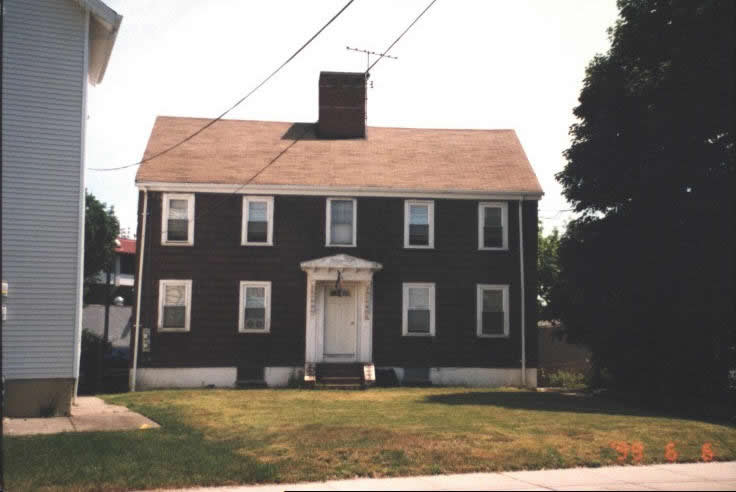 This is the home of James Bucklin 1694-1738 and his wife Mary Yields. In 1999, It still stands in Pawtucket, at 36 Columbus Ave, although altered. The original plan frame, with a central chimney and two stories with a gable roof still remains. This was a substantial house for the time, and indicates relative wealth.
Later, this James and Mary Bucklin home was a home of their son Nehemiah. This Nehemiah was called “of the brook” to distinguish him from the many other Nehemiahs in the family. (e.g., Joseph Bucklin 1662-1729 had a son Joseph who in turn had a son Nehemiah and also a son Joseph who in turn who had a son Nehemiah. Family gatherings must have been a real interesting time!) The brook referred to in the nickname of this son of James and Mary is shown in old maps as “Bucklin’s Brook”. This house stood along side of Bucklin’s Brook.
See more pictures of the Bucklin family original 600 acres in Rhode Island.